Exercise 2
Topographic Maps II
Objectives:
1) To learn to interpret contour lines
2) learn how to figure stream gradients.
3) Learn how to interpret information on topo maps.
Contours
Contour lines, which show the shape, elevation, and slope of the land surface are a unique characteristic of topographic maps. Contour lines are a means of representing vertical relief of flat paper. Each contour line is composed of points which are all the same elevation. A contour interval is the vertical distance separating successive contour lines. Contour intervals vary on different maps, depending on the ruggedness of the terrain. Often a large interval is chosen in areas of steep slopes and a small interval is used in comparatively level areas.
Contour Line Rules
* As contour lines get closer together, the terrain on the ground surface becomes steeper (and vice versa).
* Contour lines generally are not angular, due to the forces of nature such as weathering and erosion that tend to round surficial features.
* Every contour line closes on itself, either within or beyond the limits of the map.
* Contour lines only cross one another at overhanging cliffs; they may merge at vertical cliffs.
* When contour lines cross streams, they “V” or point upstream.
* Hatchured contours denote depressions.
* The elevation of a depression contour is the same as that of the adjacent lower contour, unless otherwise marked.
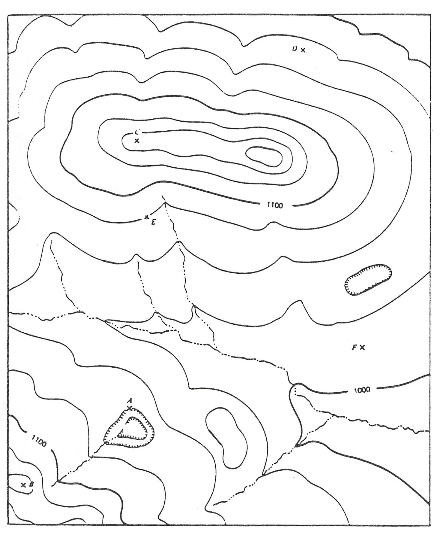
1) Referring to figure 1. (below)
a) What is the contour interval used on the map?__________
b) Give the elevation of the contour at point E. ___________
c) Give the elevation of the contour at point A.___________
d) Estimate the elevation at point D. _________
e) Estimate the elevation at point F. ________
f) Estimate the elevation at point C. __________
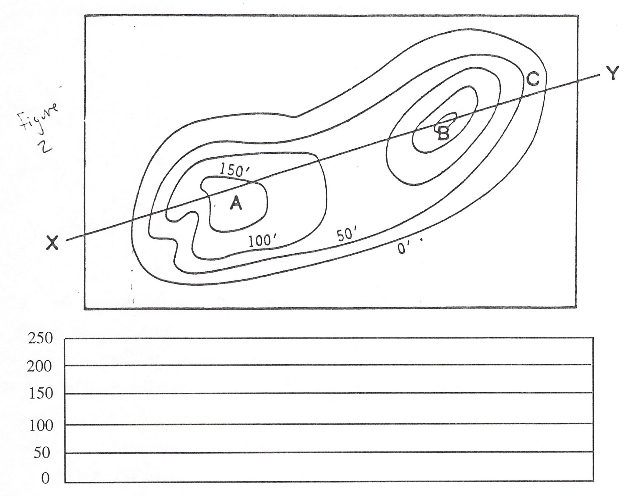
2) a) On figure 2 (below), sketch the topographic profile for line XY.
b) What is the elevation at point B? __________
c) What is the elevation at point A? ___________
3) Draw your own contour map of an island with the following description: The scale is one inch equals three miles. The contour interval is twenty five feet, the island is rectangular in shape, being 18 miles long in the east-west direction and 12 miles wide in the north/south direction. There is a circular hill on the western half of the island and its summit is 140 feet high. This hill is very steep on its northern side and very gentle on its southern side. The highest elevation on the eastern half of the island is 60 feet.
Stream Gradient: is the elevation change of the stream per unit of horizontal stream distance. It may be stated as feet / mile or meters / kilometer. To find it as a percentage, common units must be used (i.e. ft/mi would have to be changed to ft/ft).
stream gradient = elevation distance / distance on ground
4) What is the stream gradient between two points along a stream that are 2 miles apart and have a 500 foot difference in elevation?
a) in ft/mi ________
b) As a percentage (remember 5280 ft/mi) _________
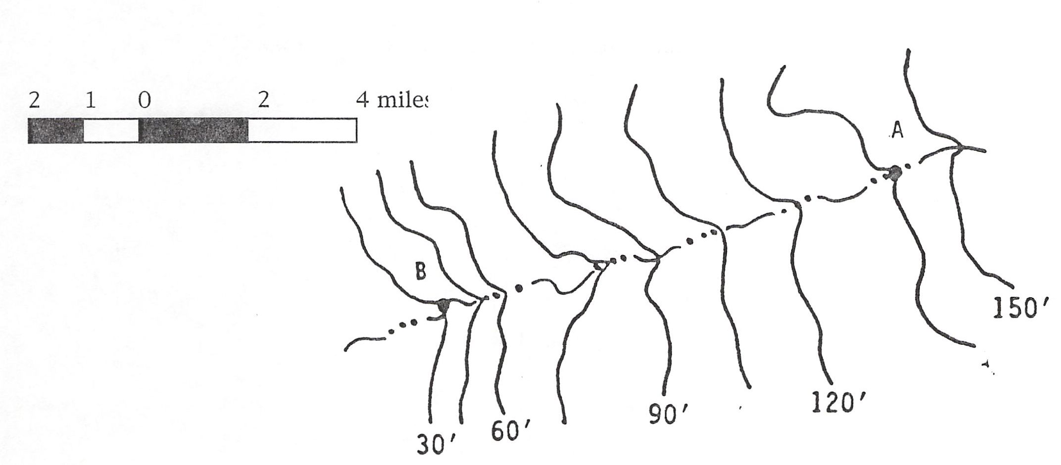
5) What is the gradient of the stream from point A to point B? (figure below)
a) in ft/mi _____________
b) as a percentage ______________
1) What is the contour interval on this map?
2) What direction does the stream in Long Tom Canyon flow? (give me an actual compass direction in degrees - best guess for about a mile uphill from the mouth of the canyon).
3) What is the elevation of Thrall (assume the "R" in Thrall)?
4) What is the elevation of the High School (the school marker just N of the E Capital Ave label)?
5) What is the gradient of Manastash Creek (NW corner of the map from the west edge of the map to Brown Road)? Assume that the stream is straight between these two points. Give it as both ft/mile and as a percentage.
6) What is the gradient of the stream flowing in Long Tom Canyon - from the 2500 foot elevation contour to where it enters the West Side Canal (the higher elevation irrigation ditch)? Again, assume the stream is straight between these two points. Give it as both ft/mile and as a percentage.